
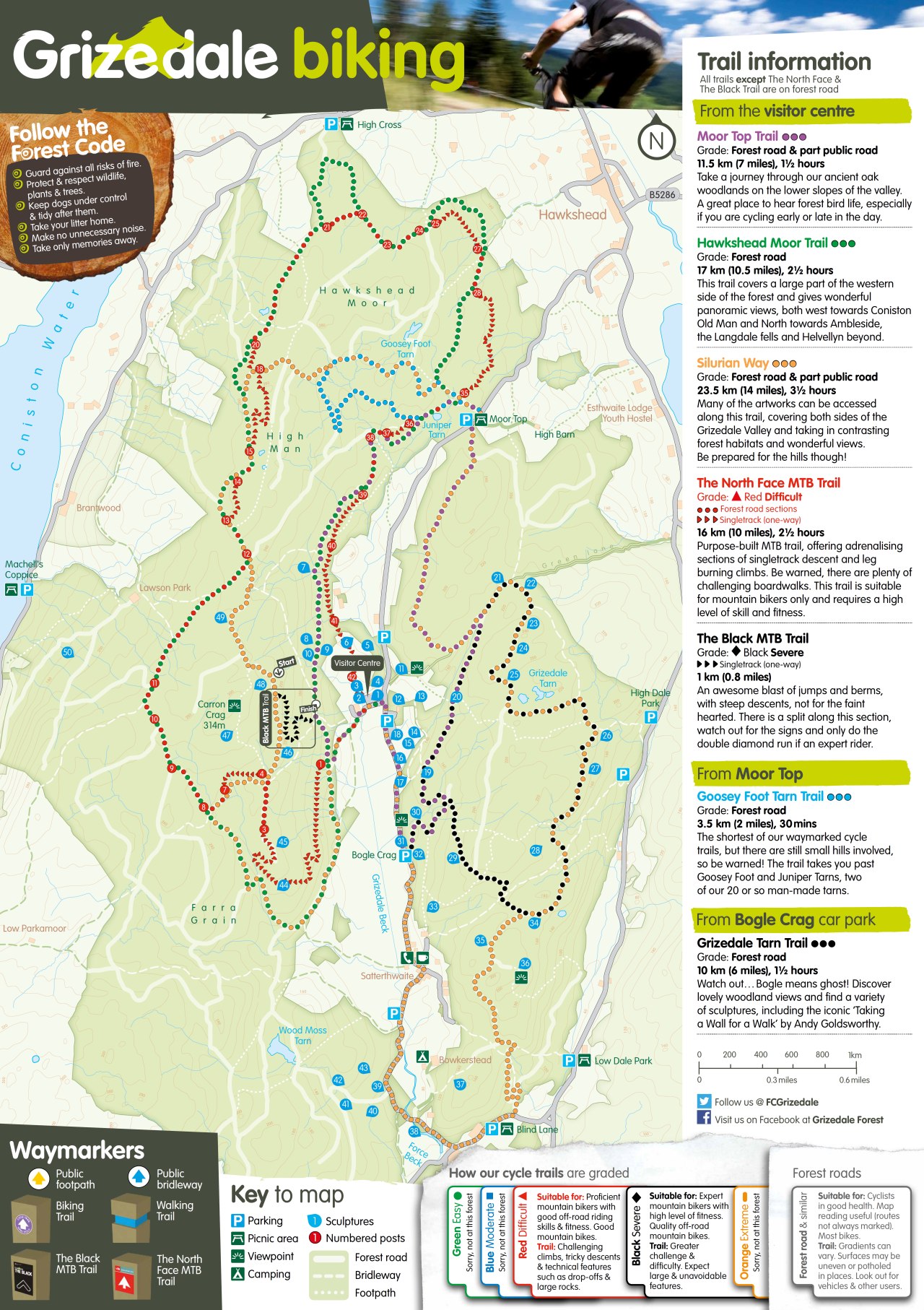
Silurian Way at Grizedale
Trail Summary:
- Ride Time: 3hrs 30 mins
- Ride Distance: 22412 m
- Ride Climb: 542 m
- Ride Descent: -542 m
-
Route Starts from: Grizedale Mountain Bike Centre
PDF Map Download
Don’t forget a Map, GPS and Guidebook!


Ride Details
The Silurian Way trail at Grizedale forest is the longest of the six green waymarked routes at around 22km in length and a hefty 550m in ascent! That’s tough for a green route, but remember that the grade of a mountain bike route always refers to how technical it is and not how physically exhausting it is. This trail provides plenty of opportunity to see the artworks, if you can find them, and you can take it at a leisurely pace in order to take it all in.
The route is somewhat spoiled by the final return along the road – though a quick look at the map yields a few options to avoid it, which the official route probably should have followed in the first place. On the plus side, it does mean that the trail passes thorugh Satterthwaite with the conveniently located The Eagles Head! The Silurian Way is waymarked in Orange.
The Silurian Way at Grizedale – Many of the artworks can be accessed along this trail, covering both sides of the Grizedale Valley and taking in contrasting
forest habitats and wonderful views. Be prepared for the hills though!
Featured Image Credit: Photo by alx_chief on Foter.com / CC BY-SA


Ride Map and Elevation Profile
Download file for GPSRemember that you can download the GPX File for the MTB route above and use in your GPS device or on your favourite mapping app. We’ll have a run down of how to use GPX files on your MTB route soon.
Base Summary: Grizedale Mountain Bike Centre
Grizedale along with Whinlatter near Keswick, is one of two MTB centres in the Lake District run by Forestry England. It is located between Coniston Water and Windermere, a few miles south of the village of Hawkshead. Grizedale is a family oriented centre, with numerous easy forestry road routes and only two technical routes for more accomplished MTB riders. Though there are a number of unofficial off-piste routes and enduro lines such as The Viking as well as an extensive network of bridleways to be explored.